- Introduction
globe is a library for mathematical modelling of 3D Earth topographical surfaces from large datasets: DEMs, clouds of point data, elevation contours.
globe extends surfit with DEM reading support from common formats and two gridding rules. See globe gridding rules and commands for DEMs.
To start using this library you should type the command:
$ load libglobe[info sharedlibextension] |
- Grand Canyon example.
Here we consider example of Grand Canyon surface reconstruction. This examples shows how to use globe to build your own DEM from other DEM's. Shure, this example can be easily extended with other data usage (points and curves for example).
To build our DEM we select the following data:
SRTM data:
- N35W112.hgt.zip
- N35W113.hgt.zip
- N35W114.hgt.zip
- N36W112.hgt.zip
- N36W113.hgt.zip
- N36W114.hgt.zip
- N37W112.hgt.zip
- N37W113.hgt.zip
- N37W114.hgt.zip
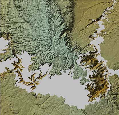
Here is an image of small region:
DTM dataset:
- usa.bin
- usa.hdr
Here is an image of small region:
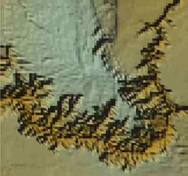
As you can see from these images, SRTM data is more detailed than DTM data. We want to combine them in the following way. We think, that DTM dataset is more precise, than SRTM data, so we want to correct SRTM data with DTM data. In areas, there is no SRTM data, we want to put DTM data and interpolate it.
We do it in three steps:
- Convert all data from other formats to surfit format, clip data for Grand Canyon region (canyon_prepare.tcl);
- Combine SRTM data as one surface (canyon_trend.tcl);
- Calculate our dem (canyon_map.tcl).
If you wish, you can download all source data for this example from here.